December 10, 2025

FacebookTwitterInstagramYouTube
  • Home
  • Events
  • NEWS
    • Top Stories
    • National News
    • National Sports
  • Contests
  • Media
    • Photos
    • Videos
  • On-Air
    • Kat & Ku`ehu
    • G. Cruz
    • Kaohu James
  • Podcasts
    • KWXX Mauna Loa Eruption Updates
    • Island Conversations
    • COVID-19 Interview
  • Contact
  • Info
  • FCC Applications
  • Advertise
  • Search
MENU
  • Home
  • Events
  • NEWS
    • Top Stories
    • National News
    • National Sports
  • Contests
  • Media
    • Photos
    • Videos
  • On-Air
    • Kat & Ku`ehu
    • G. Cruz
    • Kaohu James
  • Podcasts
    • KWXX Mauna Loa Eruption Updates
    • Island Conversations
    • COVID-19 Interview
  • Contact
  • Info
  • FCC Applications
  • Advertise
  • Search

Hector remains a Cat 4 hurricane to the SE of Hawaii, Tropical Storm watch for Hawaii County

August 7, 2018 at 5:42 am Digital Team
  • Blogs
  • Tweet
  • Share
  • Reddit
  • +1
  • Pocket
  • LinkedIn

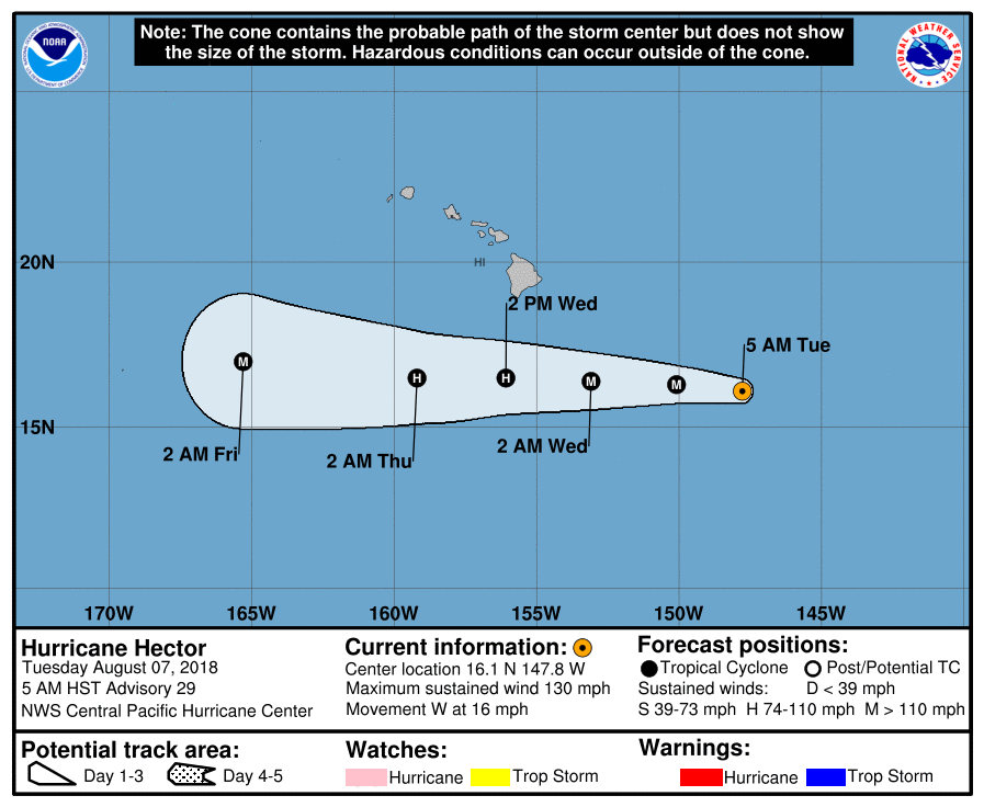
At 500 AM HST (1500 UTC), the center of Hurricane Hector was located near latitude 16.1 North, longitude 147.8 West. Hector is moving toward the west near 16 mph (26 km/h). This general motion is expected to continue through Thursday. On the forecast track, Hector is expected to pass roughly 165 miles south of the Big Island of Hawaii on Wednesday.

Maximum sustained winds are near 130 mph (215 km/h) with higher gusts.  Hector is a category 4 hurricane on the Saffir-Simpson Hurricane Wind Scale.  Some weakening is forecast during the next 48 hours.

Hurricane-force winds extend outward up to 30 miles (45 km) from the center and tropical-storm-force winds extend outward up to 90 miles (150 km).


SUMMARY OF WATCHES AND WARNINGS IN EFFECT:


A Tropical Storm Watch is in effect for Hawaii County

A Tropical Storm Watch means that tropical storm conditions are

possible within the watch area within 48 hours.

Interests elsewhere in the Hawaiian Islands should monitor the

progress of Hector.


For storm information specific to your area, please monitor products issued by the National Weather Service office in Honolulu Hawaii.


HAZARDS AFFECTING LAND

———————-

SURF:  Swells generated by Hector are expected to reach southeast and east facing shores of the Big Island and eastern Maui late today, likely becoming large and dangerous by late tonight and Wednesday.


WIND:  Tropical storm force winds are possible across Hawaii

County late tonight and Wednesday.


SUMMARY OF 500 AM HST…1500 UTC…INFORMATION

———————————————-

LOCATION…16.1N 147.8W

ABOUT 540 MI…870 KM ESE OF HILO HAWAII

ABOUT 750 MI…1210 KM ESE OF HONOLULU HAWAII

MAXIMUM SUSTAINED WINDS…130 MPH…215 KM/H

PRESENT MOVEMENT…W OR 280 DEGREES AT 16 MPH…26 KM/H

MINIMUM CENTRAL PRESSURE…947 MB…27.97 INCHES


NEXT ADVISORY

————-

Next intermediate advisory at 800 AM HST.

Next complete advisory at 1100 AM HST.


Previous Story
Hector continues westward movement, Tropical Storm Watch in effect for Hi Island
Next Story
Hurricane Hector August 7th 11AM UPDATE!

Facebook

KWXX FM

Twitter

Tweets by KWXX

"Hawaii's Feel Good Island Music Radio Station"

Info

  • Home
  • Contests
  • Socialize
  • Contact Us
  • Station Info
  • EEO
  • FCC Public File (KWXX)
  • FCC Public File (KAOY)

National News

View of Thurgood Marshall United States Courthouse where Ghislaine Maxwell trial has been heard New York^ NY - december 21^ 2021

Fed. judge grants release of grand jury evidence in Ghislaine Maxwell case

ACLU - AMERICAN CIVIL LIBERTIES UNION - sign at entrance to DC office. WASHINGTON^ DC - JANUARY 19^ 2019

Coalition of advocacy groups file lawsuit against Trump Admin. to disclose legal...

Social

Facebook Facebook Twitter Twitter Instagram Instagram YouTube YouTube
KWXX – Hilo, HI © 2025 Powered by OneCMS™ | Served by InterTech Media LLC
Are you still listening?
3628718199
Mozilla/5.0 AppleWebKit/537.36 (KHTML, like Gecko; compatible; ClaudeBot/1.0; +claudebot@anthropic.com)
9582afec4de5353cd643c6f5be6a6b79738d091d
1
Loading...