July 7, 2025

FacebookTwitterInstagramYouTube
  • Home
  • Events
  • NEWS
    • Top Stories
    • National News
    • National Sports
  • Current Contests
  • Photos/Video
    • Photos
    • Videos
  • On-Air
    • Kat & Ku`ehu
    • G. Cruz
    • Kaohu James
  • Podcasts
    • KWXX Mauna Loa Eruption Updates
    • Island Conversations
    • COVID-19 Interview
  • Contact
  • Info
  • Search
  • FCC Applications
MENU
  • Home
  • Events
  • NEWS
    • Top Stories
    • National News
    • National Sports
  • Current Contests
  • Photos/Video
    • Photos
    • Videos
  • On-Air
    • Kat & Ku`ehu
    • G. Cruz
    • Kaohu James
  • Podcasts
    • KWXX Mauna Loa Eruption Updates
    • Island Conversations
    • COVID-19 Interview
  • Contact
  • Info
  • Search
  • FCC Applications

Dept of Health releases COVID-19 location maps

March 31, 2020 at 11:26 am sbracken
  • Blogs
  • Covid-19
  • Tweet
  • Share
  • Reddit
  • +1
  • Pocket
  • LinkedIn
covid_map-2048x1583

The Hawaii State  Department of  Health has now released maps showing where COVID-19 cases are on each island.

On the Big Island, with 15 cases per the State Department of Health and  17 per Hawaii County Mayor Harry Kim,  most of the cases are mapped on the Kona side of the island.  The map data is as  of Sunday, Mar. 29, and shows the  14 cases where the patient’s location is known.
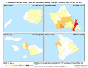
Department of Health stresses that the risk of transmission of COVID-19 is NOT limited to areas where there are more cases.  Social distancing, staying 6 or more feet away  from others, is proving to be the best way to limit exposure and slow the spread of this virus.   Because COVID-19  comes from a novel, or new, coronavirus, that just began spreading to humans around December, people have had no chance to develop immunity and no vaccine is available.   So no matter where you are, social distancing, working from home, staying away from others  as much  as possible, is critical.

The State Department of Health COVID-19 information site updates at noon  daily, to reflect the current cases, locations, and information about COVID-19 and  how to follow “best  practices” to slow the  curve on the island and in the state.

Tags: COVID-19 map
Previous Story
Humane Society needs foster parents
Next Story
DOH stats: 1 death, 224 cases in state

Facebook

Twitter

Tweets by KWXX

"Hawaii's Feel Good Island Music Radio Station"

Info

  • Home
  • Contests
  • Socialize
  • Contact Us
  • Station Info
  • EEO
  • FCC Public File (KWXX)
  • FCC Public File (KAOY)

National News

Working traffic lights over flooded Houston streets and boats with people at sunset. Texas^ USA

Death toll rises to over 80 after devastating central Texas flash flooding

crime or accident scene sign do not pass the line with police cars in the background

2 teens killed, 5 wounded after mass shooting in Indianapolis

Social

Facebook Facebook Twitter Twitter Instagram Instagram YouTube YouTube
KWXX – Hilo, HI © 2025 Powered by OneCMS™ | Served by InterTech Media LLC
Are you still listening?
3628718276
Mozilla/5.0 AppleWebKit/537.36 (KHTML, like Gecko; compatible; ClaudeBot/1.0; +claudebot@anthropic.com)
8fb11970c123132cbe4e7927865a4fbbb53cc4c8
1
Loading...