May 17, 2025

FacebookTwitterInstagramYouTube
  • Home
  • Events
  • NEWS
    • Top Stories
    • National News
    • National Sports
  • Current Contests
  • Photos/Video
    • Photos
    • Videos
  • On-Air
    • Kat & Ku`ehu
    • G. Cruz
    • Kaohu James
  • Podcasts
    • KWXX Mauna Loa Eruption Updates
    • Island Conversations
    • COVID-19 Interview
  • Contact
  • Info
  • Search
  • FCC Applications
MENU
  • Home
  • Events
  • NEWS
    • Top Stories
    • National News
    • National Sports
  • Current Contests
  • Photos/Video
    • Photos
    • Videos
  • On-Air
    • Kat & Ku`ehu
    • G. Cruz
    • Kaohu James
  • Podcasts
    • KWXX Mauna Loa Eruption Updates
    • Island Conversations
    • COVID-19 Interview
  • Contact
  • Info
  • Search
  • FCC Applications

Where on Hawaii Island are active COVID cases?

July 2, 2020 at 1:04 pm sbracken
  • Blogs
  • Covid-19
  • Tweet
  • Share
  • Reddit
  • +1
  • Pocket
  • LinkedIn
map-of-28-day-cases_2020-07-02

The Hawaii State Department of Health often does not release information about where the newest COVID-19 cases are on an island, except in special situations.  They do publish a map of where all the county’s cases have been….just below is the map reflecting the locations of the residence or place of lodging of all the Big Island’s confirmed 90 victims since the COVID counting began.  Note that out of the 90 cases, 4 are currently active as of today:
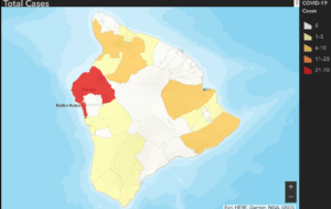
 

The red area have had 21 to 70 cases, the gold areas have 6 to 10 cases, and the yellow areas have 1 to 5.  The white areas have zero.

The State DOH also provides a map of where the cases are within the past 28 days.  Four weeks ago, the county had 81 cases; today there are 90, with 4 active.  The map below shows where the 9 cases confirmed within the last 4 weeks are located, with the yellow areas having 1 to 5 and the white areas having 0.
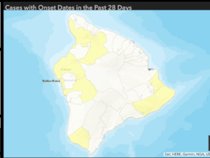
The State DOH notes that the person’s residence or place of lodging may not be where they were exposed to the novel coronavirus which led to them having COVID-19 and urges everybody to wear a mask in public and practice social isolation to keep COVID-19 under control as much as possible.  On the Big Island, the map indicates there are people all around the island who have or have had COVID-19.

The original maps are on the State Department of Health COVID-19 dashboard.

Tags: COVID-19 Hawaii County, COVID-19 map
Previous Story
Big Island now has 4 active cases–state added 20 COVID cases today
Next Story
Mayor Caldwell mandating face coverings for O’ahu

Facebook

Twitter

Tweets by KWXX

"Hawaii's Feel Good Island Music Radio Station"

Info

  • Home
  • Contests
  • Socialize
  • Contact Us
  • Station Info
  • EEO
  • FCC Public File (KWXX)
  • FCC Public File (KAOY)

National News

Sign in support of Milwaukee Judge Hannah Dugan at a May Day march for workers' rights in Lower Manhattan. NEW YORK^ NEW YORK USA - May 1^ 2025

Wisconsin Judge Hannah Dugan pleads not guilty to federal obstruction charges

US Supreme court building on the capitol hill in Washington DC^ United States of America

Supreme Court expresses concern over Trump’s birthright citizenship plan amid ...

Social

Facebook Facebook Twitter Twitter Instagram Instagram YouTube YouTube
© 2025 KWXX - Hilo, HI Powered by OneCMS™ | Served by InterTech Media LLC
Are you still listening?
51270600
Mozilla/5.0 AppleWebKit/537.36 (KHTML, like Gecko; compatible; ClaudeBot/1.0; +claudebot@anthropic.com)
64820d140f6a9f0452489a11a1abfd1bca049b50
1
Loading...