June 20, 2025

FacebookTwitterInstagramYouTube
  • Home
  • Events
  • NEWS
    • Top Stories
    • National News
    • National Sports
  • Current Contests
  • Photos/Video
    • Photos
    • Videos
  • On-Air
    • Kat & Ku`ehu
    • G. Cruz
    • Kaohu James
  • Podcasts
    • KWXX Mauna Loa Eruption Updates
    • Island Conversations
    • COVID-19 Interview
  • Contact
  • Info
  • Search
  • FCC Applications
MENU
  • Home
  • Events
  • NEWS
    • Top Stories
    • National News
    • National Sports
  • Current Contests
  • Photos/Video
    • Photos
    • Videos
  • On-Air
    • Kat & Ku`ehu
    • G. Cruz
    • Kaohu James
  • Podcasts
    • KWXX Mauna Loa Eruption Updates
    • Island Conversations
    • COVID-19 Interview
  • Contact
  • Info
  • Search
  • FCC Applications

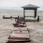
Millions without power in Florida after Hurricane Ian makes landfall, causing life-threatening storm surges, catastrophic flooding and devastating winds

September 29, 2022 at 12:57 am Staff
  • News Daypop
  • Tweet
  • Share
  • Reddit
  • +1
  • Pocket
  • LinkedIn
shutterstock_1264315294-1

Hurricane Ian was downgraded to a tropical storm Thursday morning after leaving a path of destruction across Florida with life-threatening storm surges, trapping people in flooded homes and knocking out power to 2 million people.

Ian made landfall near Cayo Costa around 3 p.m. Wednesday as a powerful Category 4 hurricane with 150 mph winds; the storm is believed to be one of the strongest hurricanes ever recorded making landfall in Florida. The massive storm also brought torrential rainfall, and a catastrophic storm surge that left entire coastal communities under feet of water. Ian was the first Category 4 hurricane in the Gulf of Mexico since Rita in 2005.

Officials warned, however, that the powerful storm was not over. Early Thursday, the National Hurricane Center reported that Ian had maximum sustained winds of near 65 mph with higher gusts as it moved slowly through central Florida on its way to the western Atlantic.  By 5 a.m., Ian was around 55 miles southwest of Cape Canaveral and moving northeast at 9 mph, the hurricane center said. Florida’s Atlantic coast, from northeast of Orlando into Georgia, could see a 6-foot storm surge. The storm is moving toward the northeast near 8 m.p.h., with a turn toward the north-northeast – and a move off the coast of Florida – expected later today. It’s expected to pick up speed during the day on Friday and into the evening as it approaches the coast of South Carolina.

Life-threatening storm surges and hurricane conditions were possible on Thursday and Friday along the coasts of northeast Florida, Georgia, and South Carolina, where Ian was expected to move inland. The governors of South Carolina, North Carolina, Georgia and Virginia all preemptively declared states of emergency.

Editorial credit: John Connor Bray / Shutterstock.com

Previous Story
Justice Department seizes 10 million fake fentanyl-laced pills
Next Story
COVID-19 Reinfection Rate Rising

Facebook

Twitter

Tweets by KWXX

"Hawaii's Feel Good Island Music Radio Station"

Info

  • Home
  • Contests
  • Socialize
  • Contact Us
  • Station Info
  • EEO
  • FCC Public File (KWXX)
  • FCC Public File (KAOY)

National News

Mother giving cough syrup to her sick son in bed

‘Little Remedies’ children’s cough syrup recalled over possible bacterial ...

Photo illustration of TikTok logo displayed on a smartphone with American Flag in the background.

President Trump extends TikTok ban deadline for third time

Social

Facebook Facebook Twitter Twitter Instagram Instagram YouTube YouTube
KWXX – Hilo, HI © 2025 Powered by OneCMS™ | Served by InterTech Media LLC
Are you still listening?
3628718268
Mozilla/5.0 AppleWebKit/537.36 (KHTML, like Gecko; compatible; ClaudeBot/1.0; +claudebot@anthropic.com)
6978b8f55b95018e29b2e97dd03c07fe75e59e06
1
Loading...