June 5, 2025

FacebookTwitterInstagramYouTube
  • Home
  • Events
  • NEWS
    • Top Stories
    • National News
    • National Sports
  • Current Contests
  • Photos/Video
    • Photos
    • Videos
  • On-Air
    • Kat & Ku`ehu
    • G. Cruz
    • Kaohu James
  • Podcasts
    • KWXX Mauna Loa Eruption Updates
    • Island Conversations
    • COVID-19 Interview
  • Contact
  • Info
  • Search
  • FCC Applications
MENU
  • Home
  • Events
  • NEWS
    • Top Stories
    • National News
    • National Sports
  • Current Contests
  • Photos/Video
    • Photos
    • Videos
  • On-Air
    • Kat & Ku`ehu
    • G. Cruz
    • Kaohu James
  • Podcasts
    • KWXX Mauna Loa Eruption Updates
    • Island Conversations
    • COVID-19 Interview
  • Contact
  • Info
  • Search
  • FCC Applications

Blizzard conditions in Northern California shuts down roads, ski resorts

March 4, 2024 at 1:05 am Staff
  • News Daypop
  • Tweet
  • Share
  • Reddit
  • +1
  • Pocket
  • LinkedIn
"Road Closed" sign during atmospheric river winter storm event in the Sierra Nevada mountains.

Blizzard conditions have continued to slam the Northern California region throughout the weekend with damaging winds and heavy snow, shutting down roads and ski resorts across the area.  Around 6.5 million people were under winter weather alerts across the Mountain West, with blizzard warnings still in effect for the Sierra Nevada, who have experienced the most extreme weather including whiteout conditions and hurricane-force winds.

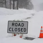
The blizzard closed a 70-mile stretch of Interstate 80 near the Nevada state line for more than a day, with the Weather Center adding that “extremely heavy snowfall rates of 2-6 inches an hour combined with very strong winds exceeding 100 mph at times will maintain impossible travel conditions in the Sierra Nevada” and warned of “high to extreme” avalanche danger in the Central Sierra and Greater Lake Tahoe area. About 5-12 feet of snow was forecast to fall along the crest of the Sierra with damaging wind gusts “possibly in excess of 75 mph” expected across the Intermountain West.

Numerous ski areas were closed over the weekend including at Palisades Tahoe, Sierra at Tahoe and Mammoth. The National Weather Service said on Sunday that “winds will wane in intensity, though some additional heavy snowfall is expected through the day, particularly for the southern Cascades/Sierra, Wasatch, and central Rockies.”  Extreme snowfall and roaring winds in the Sierra and parts of the northern ranges mean blowing snow and whiteout conditions making travel “impossible.”

While the storm was expected to wind down on Sunday, it will be followed by a new system on Monday, the National Weather Service said.

Editorial credit: DNB STOCK / Shutterstock.com

Previous Story
University of Florida terminates all DEI positions to comply with state law
Next Story
Kea‘au Man Arrested and Charged With Terroristic Threatening

Facebook

Twitter

Tweets by KWXX

"Hawaii's Feel Good Island Music Radio Station"

Info

  • Home
  • Contests
  • Socialize
  • Contact Us
  • Station Info
  • EEO
  • FCC Public File (KWXX)
  • FCC Public File (KAOY)

National News

House Speaker Mike Johnson (R-LA) in National Statuary Hall at the U.S. Capitol. WASHINGTON — March 4 2025

CBO says Trump’s “One Big Beautiful Bill” could inflate deficit by $2.4 Tr...

Rows of Steel Round Bar storage and stacking in the warehouse for industrial construction.

U.S. tariffs go into effect; doubling to 50% on steel, aluminum

Social

Facebook Facebook Twitter Twitter Instagram Instagram YouTube YouTube
© 2025 KWXX - Hilo, HI Powered by OneCMS™ | Served by InterTech Media LLC
Are you still listening?
3628718325
Mozilla/5.0 AppleWebKit/537.36 (KHTML, like Gecko; compatible; ClaudeBot/1.0; +claudebot@anthropic.com)
ef1f89d5a0de3000e36715784245c4d5b7aa29cc
1
Loading...